When a Homeowner Discovers a Dam
Small, Low-Head, and Hidden Dams: How to Identify, Screen, Manage, and Regulate Them
Originally prepared on March 27, 2026; expanded on March 29 and 30, 2026
Qizhong (George) Guo
Rutgers University–New Brunswick
Introduction
An article published on NJ.com, which included comments from the author, highlighted cases in which New Jersey homeowners discovered that a dam or dam-like structure existed on their property—sometimes only after completing a home purchase. These situations can lead to unexpected responsibilities, including inspection, maintenance, and potentially significant repair costs.
In some cases, homeowners unknowingly acquire not only land and a residence, but also responsibility for a dam. Required inspections, repairs, or potential removal can involve substantial costs. The article also discusses proposed legislation in New Jersey that would require disclosure of dams during real-estate transactions.
While such cases may appear unusual, they reflect broader characteristics of water infrastructure in the United States that are not always visible in public discussions.
This brief provides technical and historical context on dams, explains how they are identified and regulated, and clarifies why these situations can arise.
Dam Inventories in the United States
The United States maintains several overlapping inventories of dams. The most widely known is the National Inventory of Dams (NID), maintained by the U.S. Army Corps of Engineers, which lists more than 90,000 dams nationwide.
However, the NID includes only dams that meet specific size or hazard thresholds. Many smaller structures are excluded. Researchers have therefore developed inventories such as the Low-Head Dam Inventory to identify small dams that may pose safety risks but do not appear in regulatory databases.
When very small structures are considered, the total number of dams in the United States may exceed several hundred thousand.
The Case of New Jersey
New Jersey provides an instructive example of how these inventories differ.
- The NID lists about 830 dams in the state.
- The New Jersey Department of Environmental Protection regulates approximately 1,745 dams, including smaller structures not captured in the national inventory.
A significant portion of these dams are privately owned, including many earthen embankment dams that may not be immediately recognizable as infrastructure.
Historical Role and Positive Contributions of Small Dams
Small dams played an important role in American economic history. During the eighteenth and nineteenth centuries, rivers powered:
- grist mills
- sawmills
- textile mills
- iron works
These dams created mill ponds and hydraulic head for water-powered industry.
Even after many mills disappeared, the dams remained as part of the landscape. Over time, mill ponds became scenic lakes or recreational areas, and low-head dams contributed to recognizable landscape features such as small waterfalls.
In this sense, historic dams are not only infrastructure but also part of cultural and landscape heritage.
Dam Disclosure Approaches
States have adopted different approaches to disclosure of dams in residential real-estate transactions:
- Virginia: buyer-beware approach
- Connecticut: disclosure of registered dams required
- New Jersey (proposed): more detailed disclosure, including:
- whether a dam exists
- hazard classification
- inspection history
- ownership responsibilities
These requirements are intended to improve transparency and reduce unexpected obligations for homebuyers.
An additional consideration is the distinction between dams or embankments located in upland areas (e.g., small ponds or drainage features) and those spanning significant streams. This distinction can influence decisions on maintenance, rehabilitation, or removal, as such structures may affect both upstream and downstream conditions—including fish migration, water quality, sediment transport, flooding, and public safety (e.g., hazards to boaters and recreational users). It also highlights the importance of clearly defining what constitutes a “dam” in disclosure frameworks, particularly in the context of proposed legislation in New Jersey.
Practical Challenges
Although disclosure may appear straightforward, practical challenges arise.
- Many homeowners may not know whether a small embankment legally qualifies as a dam
- Records for older structures may be incomplete
- Responsibilities vary by size, hazard classification, and jurisdiction
- Some structures resemble natural landscape features
These factors make the first disclosure question—whether a dam exists on the property—more complex than it initially appears.
How an Engineer Might Visually Screen for a Dam in the Field
For a homeowner or buyer walking a property, the first step is not legal classification, but recognizing whether the landscape shows evidence of a man-made embankment designed to impound water.
Typical indicators include:
-
Outlet or spillway structures
(culvert pipe, concrete drop, stone overflow, localized waterfall) -
Crest or top berm
(flat or gently rounded top separating upstream and downstream) -
Side or emergency spillway
(low channel or saddle for overflow) -
Downstream indicators
(wet areas, seepage, erosion, or scour) -
Man-made materials or geometry
(riprap, concrete, pipes, or regular linear edges)
These features suggest that a water body is impounded rather than naturally formed.
However, visual observation alone does not determine legal classification.
Using Modern Tools to Screen for Dams and Embankments
Modern geospatial tools can complement field observations:
- Aerial and satellite imagery identify impounded water bodies and linear features
- Digital elevation models (DEMs) detect subtle embankments and terrain changes
- Machine learning, artificial intelligence (AI), and computer vision are increasingly used to identify small dams
Low-head dams—sometimes referred to as “drowning machines”—can be difficult to detect visually but may pose significant hazards.
These tools are effective for screening large areas but do not replace on-the-ground inspection.
Example: A Mid-20th Century Pond at the Institute for Advanced Study
The pond behind the Institute for Advanced Study (IAS) in Princeton provides an illustrative example.
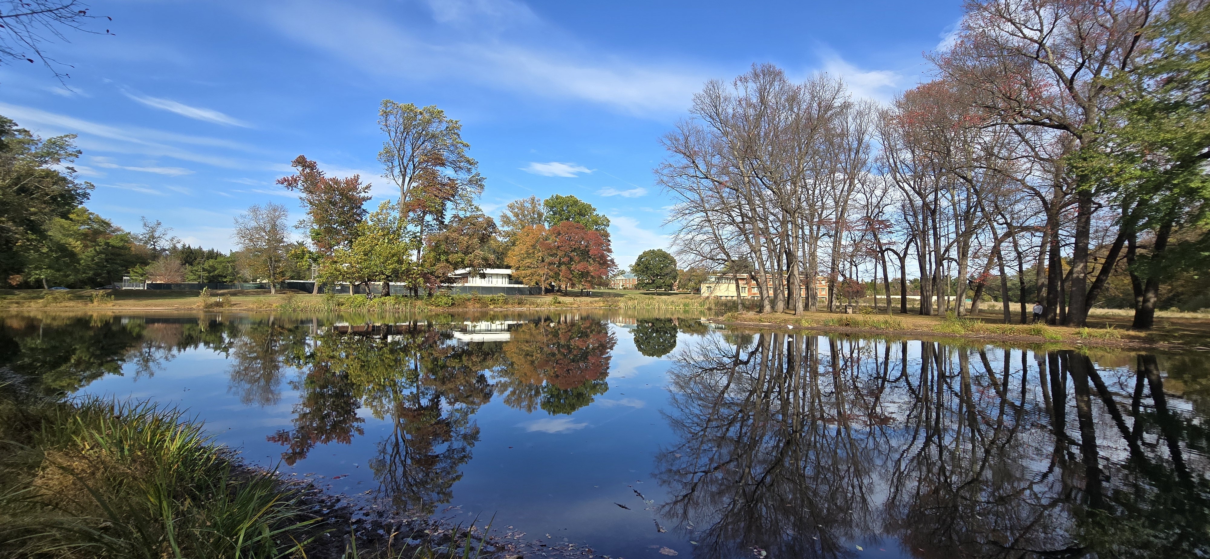
Figure 1. IAS pond in Princeton, New Jersey. While it appears natural, it is formed and maintained by a man-made embankment dam and outlet structure. Photo by the author, October 18, 2025.
Historical and aerial imagery indicate:
- 1930s → no pond present
- 1980s → pond clearly visible
This confirms that the pond is a mid-20th century embankment structure, not a historic farm pond.
Field observations further reveal:
- a constructed outlet structure
- a well-defined earthen embankment and crest
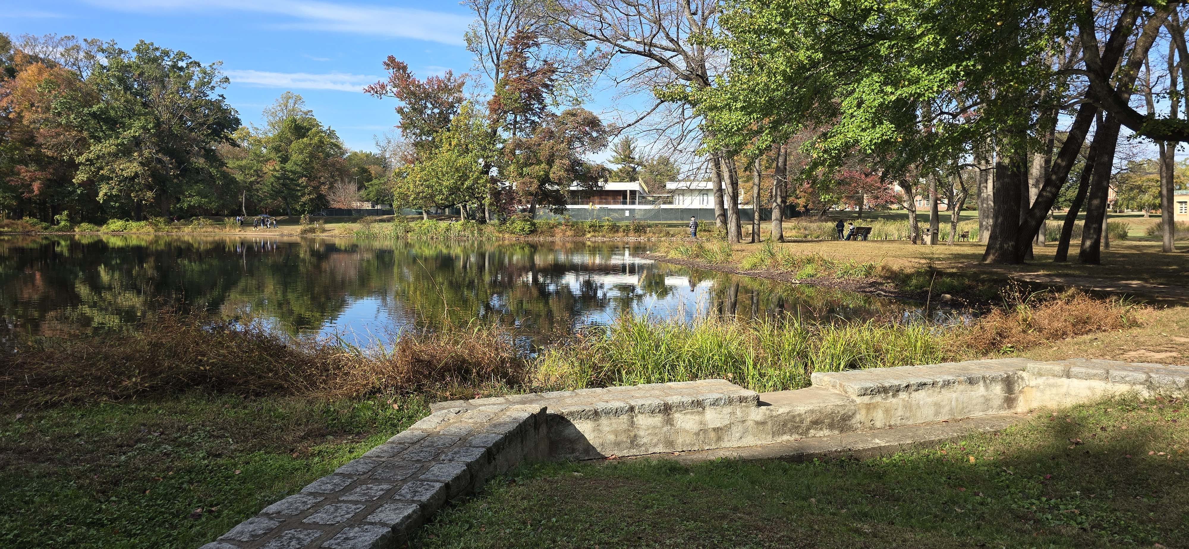
Figure 2. Outlet structure of the IAS pond showing controlled discharge. Photo by the author, October 18, 2025.
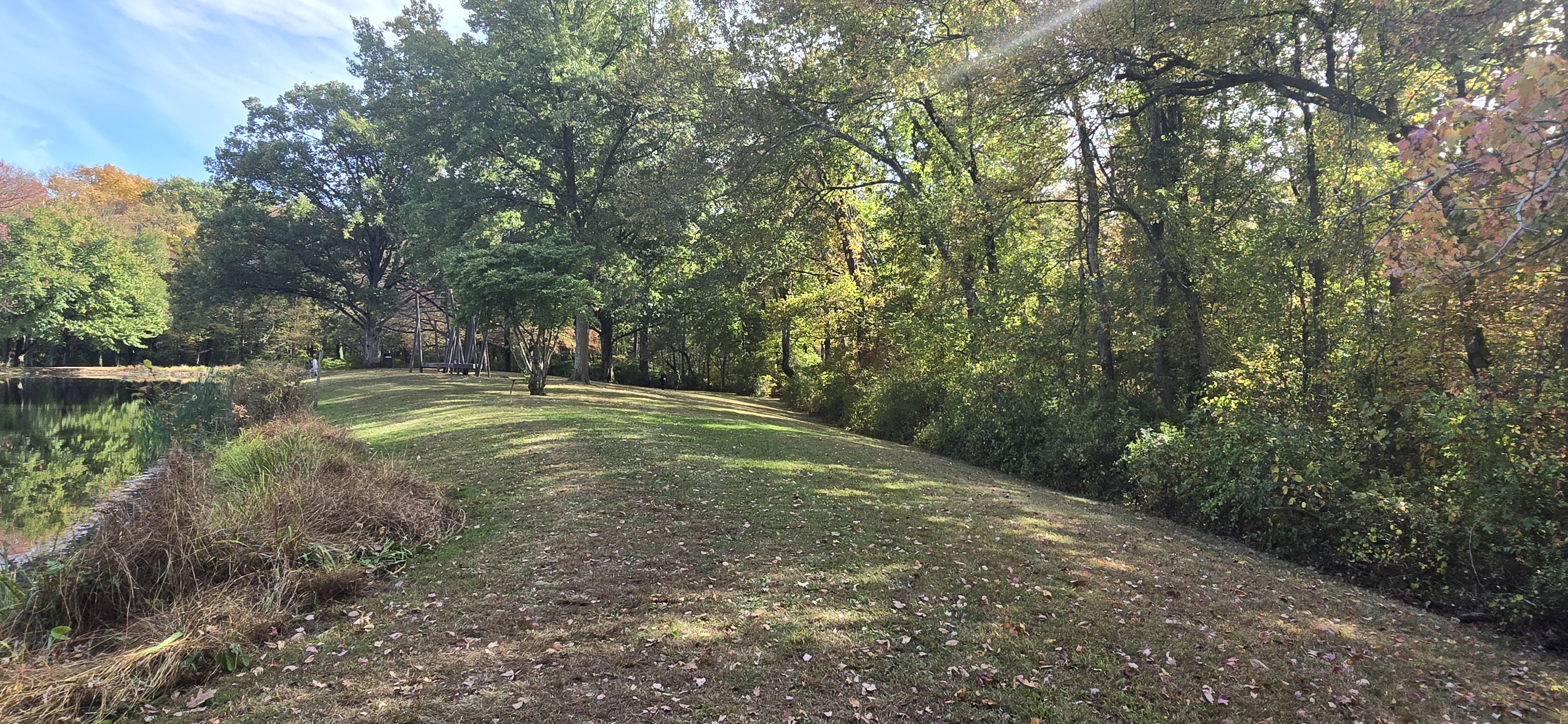
Figure 3. Earthen embankment (dam) of the IAS pond, showing crest and downstream slope. Photo by the author, October 18, 2025.
Albert Einstein worked at the Institute from 1933 to 1955, prior to the pond’s construction. During his time, the area would have been open landscape, although he was known to walk extensively in the nearby Institute Woods.
This example illustrates how relatively recent infrastructure can become visually integrated into the landscape and may not be readily recognized as a dam.
Infrastructure Responsibilities and Risks
When a dam is present, the primary issue is not simply its existence, but the responsibilities associated with it.
Owners may be required to:
- conduct periodic inspections
- maintain structural stability
- manage vegetation and drainage
- ensure safe passage of water
Failure to maintain even a small dam can lead to:
- localized flooding
- erosion
- damage to nearby infrastructure
For higher-hazard dams, consequences can be significantly more severe.
Reflection
Dams represent a significant but often hidden layer of infrastructure embedded within the American landscape.
Some date back centuries, while others—like the IAS pond—were constructed more recently but have already become integrated into the landscape.
As land ownership changes, these structures sometimes become part of residential properties, raising questions of responsibility, risk, and disclosure.
Understanding this layered history can help homeowners, engineers, and policymakers make more informed decisions about managing, maintaining, or removing these structures.
Related Article
Final Note
This expanded brief provides additional technical, historical, and practical context for understanding how dams—particularly small and often overlooked embankments—can become part of modern residential properties and why their presence may not always be apparent during real-estate transactions.
Download:
PDF version of this brief →
Presentations of this brief by NotebookLM:
Slide_Deck →
Infographic →
Briefing_Document →
Video →